Certified Hydrographic Surveying
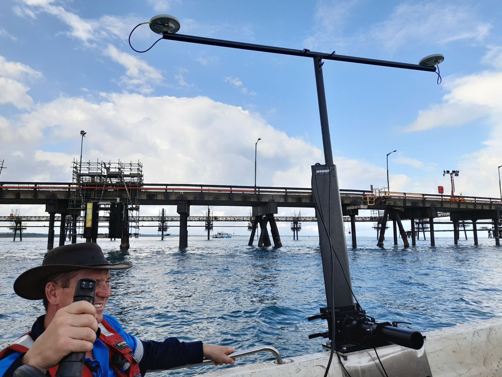
Aquamap Hydrographic Services provides expert Hydrographic Consultancy services, including using 3-D scanners and multibeam echo sounders to scan and survey any type of ocean, river, or impoundment. Using state-of-the-art surveying equipment, these innovative instruments can accurately represent underwater landscapes, thus dramatically improving our knowledge and understanding of seas, rivers, and lakes. Hydrographic survey data is essential for various purposes, such as maritime navigation, environmental assessment and management, engineering design and construction, and scientific research. As a result, the Aquamap Hydrographic Services 3-D scanners and multibeams represent the cutting edge of technology in the field of hydrography.
Unraveling the Depths: Your Experts in Hydrographic Surveying
At Aquamap Hydrographic Surveying, we understand the critical need for certified hydrographic surveying throughout Australia and the Asia Pacific region. The ocean's floor is a vast and largely unexplored territory, teeming with untapped resources and potential risks.
A detailed and accurate map of the ocean floor is crucial for safe navigation, environmental conservation, and efficient resource extraction. As an Australian-owned and -operated company, we're committed to delivering expert advice and high-quality hydrographic surveying services.
Our professional, friendly, and experienced team of Hydrographic Surveyors stands ready to meet your needs, using our wealth of experience to interpret and report on seabed information. We don't just map the ocean floor; we provide comprehensive services including environmental monitoring, tidal and current analysis, sub-bottom, and geodetic survey control.
Let us guide you through the unknown, with certified hydrographic surveying services you can trust. Contact us today for more information—you can reach us by calling Mick and the team on +61 488 299 004, or by sending us a message. We look forward to working with you.
What Are Surveys Used for:
- Coastal Observation
- Harbour Basins and Shipping Channel Observations
- Identifying Data for Maritime Facilities
- Dredging Planning
- Identifying Shipping Channels
- Developing Clearance Surveys and Charts
- Analysing River and Inland Waterway Depths
- Examining Sandbanks and Shoals
Coastal Zone & Infrastructure Management
The coastal zone is a vital part of the marine environment, and surveys are essential for understanding the needs of this ecosystem. Surveys help assess the coastline's health, identify potential threats to its integrity, and develop strategies for its protection. In recent years, technological advances have made it possible to survey large areas of the coastline more efficiently.
Hydrographic surveying is vital for the safe navigation of vessels, understanding the seabed habitat, identifying potential hazards and debris, and measuring sea levels. Aquamap has a wealth of experience in this field, and our surveys can also inform engineers on how best to design infrastructure for dredging projects and flood modelling. The Coastal Zone is a complex and ever-changing environment, and effectively managing this vital resource requires detailed knowledge and understanding. Our team of experts can provide the data you need to make informed decisions about the future of your coastal infrastructure. Contact us today to find out more.
Pipeline, Cable & Sub Sea Infrastructure
Underwater pipelines, cables and subsea structures are just a few examples of marine infrastructure critical for offshore activities such as oil and gas exploration, energy, and telecommunications.
Pipeline systems transport fluids such as oil and gas, while cable networks carry electrical power and communications signals between offshore locations. Subsea structures support pipeline and cable systems and house components such as control valves and connectors. Without these vital infrastructure components, offshore activities would be impossible.
Our Services
- Real-time Positioning
- Sediment and Seabed Sampling
- Ongoing Surveys
- Route and Site Surveys
Metocean Services
Aquamap Hydrographic Services provide high-quality data on Metocean processes to many maritime industries. Our data helps our clients to gain a clearer picture of the Metocean environment allowing them to make more informed decisions about their operations. Our services are used by various industries, including shipping, offshore oil and gas, and renewable energy.
Benefits of Metocean Services
- Reduce Engineering Uncertainties
- Enhance Project Operability and Safety
- Minimise Project Costs
Object Detection & Debris Clearance
Debris in the marine environment can come from various sources, from land-based activity to discarded fishing gear. This debris can significantly impact marine infrastructure activities, from dredging to offshore installation activities. To ensure the safety of these activities, it is essential to clear any debris from the area before proceeding. Object detection and debris clearance are crucial steps in the marine infrastructure process.
Benefits of Object Detection & Debris Clearance
- Avoid Shipping Incidents
- Fouling of Dredging and Construction Equipment
- Safe Anchorage
Dredging and Bed Leveling
Dredging and bed levelling surveys are important tools for environmental monitoring and research. Dredging surveys assess the depth of sediment in an area, while bed-levelling surveys measure the contours of the seafloor. This information is used to track changes in seafloor topography over time and to study sediment movement in response to currents, tides, and waves. The data collected by these surveys is essential for understanding the dynamics of our oceans and coasts.
- Maximising the Use and Productivity of Ports
- Plan Shipping Schedules
- Draft for Vessel Entry and Exit from the Ports
Port and Harbour
Surveying is critical to the management of all ports and harbours. By surveying the seabed, port authorities can identify changes in depth and seabed topography. This information is essential for safe navigation, as it helps to ensure that vessels have sufficient water depth to enter the port. Surveys also play a vital role in environmental management, as they can help identify seabed areas at risk of erosion or contamination. In addition, surveys can be used to assess the impact of proposed development projects on the surrounding environment.
Benefits of Surveying Ports and Harbours
- Monitors and Assess Seabed Changes
- Collect Data for Charting Purposes and Safe Navigation
- Declare Depth for Berths and Shipping Channels
- Assist Marine Construction and Dredging
Aquamap is the place to go for all your Hydrographic Solutions. Call us today on 0448 299 004.